
When the River Kept Rising: Flooding on the Skagit
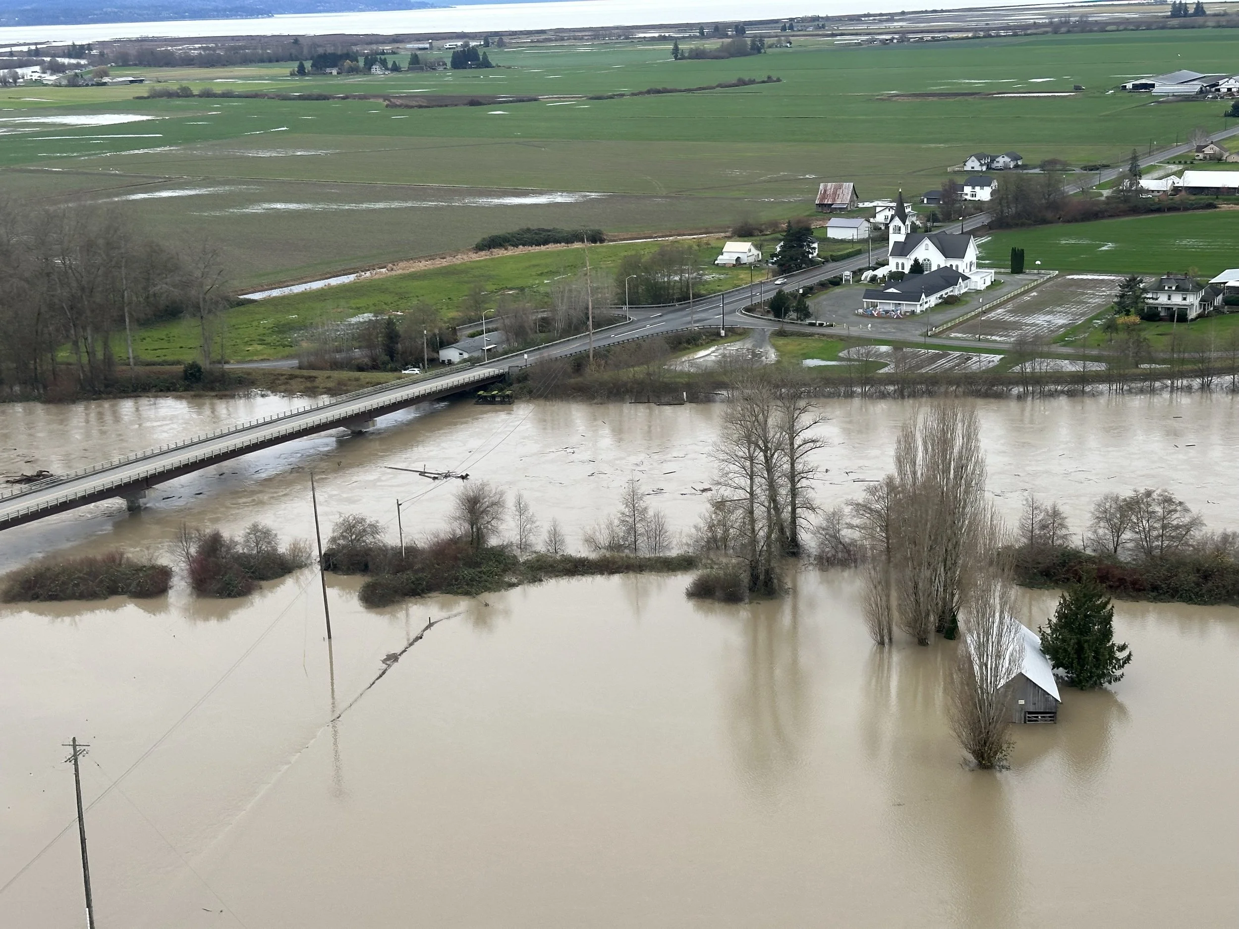
Helicopter view of the Conway bridge over the South Fork of the Skagit River, December 11, 2025. Photo: Darrin Morrison.
The rain kept falling, the Skagit River kept rising, and the weather forecast kept changing—with the expected scale of the flood growing bigger and bigger. By Wednesday, December 10, 2025, the prediction called not just for a flood, but a catastrophic one measuring 42 feet on the river in Mount Vernon, almost five feet higher than the flood of record in 1990.
“That prediction was scary,” said Daryl Hamburg who is the director of operations for Dike District 17 and the chair of the board for the county’s Dike and Drainage Flood Control Partnership. He told elected officials at a late-night briefing that they needed a plan beyond fighting the flood, because at that level, “I don’t foresee us holding that water.”
Visions of the river overtopping levees and Interstate 5 becoming submerged loomed. But Hamburg understood better than anyone that these were not the same levees that failed in 1990. After that flood showed how the districts had become complacent, they used U.S. Army Corps of Engineers rehabilitation funds to strengthen the system. In addition, the Mount Vernon flood wall, added in 2019, provided a stronger defense against downtown businesses facing feet of floodwater.
—
Skagit County prepared, but the anticipated flood’s scale required help. Resources and personnel came from the state first. Then came the National Guard.
The chain of command can get muddied in a situation like that. “It was really unclear,” said Jenna Friebel, executive director of the Skagit Drainage and Irrigation Districts Consortium, who was in the thick of it at the Emergency Operations Center.
Evacuation orders for upstream communities, such as Hamilton and Lyman, went out early on December 10. By evening, orders were issued for the delta that included some 75,000 people in the 100-year floodplain.
—
While emergency managers attempted to create order in the chaos, the reality of the flood was becoming visible on the land.
The day before the crest, Darrin Morrison, a farmer and dike commissioner, hopped aboard a National Guard Black Hawk helicopter at the Conway Fire Station.
The flight took those aboard along both forks of the Skagit. The levees were holding, but the hydraulic pressure was immense, creating boils near the levees and as much as 500 feet away in fields.
Boils emerge when the river is especially full. When this pressure is strong enough, water finds old channels, such as an old slough, and moves through the sand or gravel bed that remains buried underground. These boils emerge “maybe the size of a coffee cup” and with pressure “bigger than a garden hose but smaller than a fire hose,” Morrison said. From the helicopter, the plumes of mud from the boils were easily visible and helped distinguish where ponding in fields was just from rain or came from the river making its escape.
“The fear with those boils is they’ll start to move soil away and create this tunnel and get bigger and bigger and bigger,” Morrison explained. That could weaken the levees. Fortunately, none was large enough to require immediate action, but the districts knew where to monitor closely.
—
Upstream at Concrete, the crest came early on Thursday, December 11. The river measured 41.1 feet, a new record. A day later, Mount Vernon recorded 37.73 feet, surpassing the 1990 flood of record at 37.37 feet.
After the crest, on Friday morning, December 12, Gages Slough in Burlington flooded, leading to an immediate evacuation order, the final one of the event.
Then, Skagit waited for the water to recede.
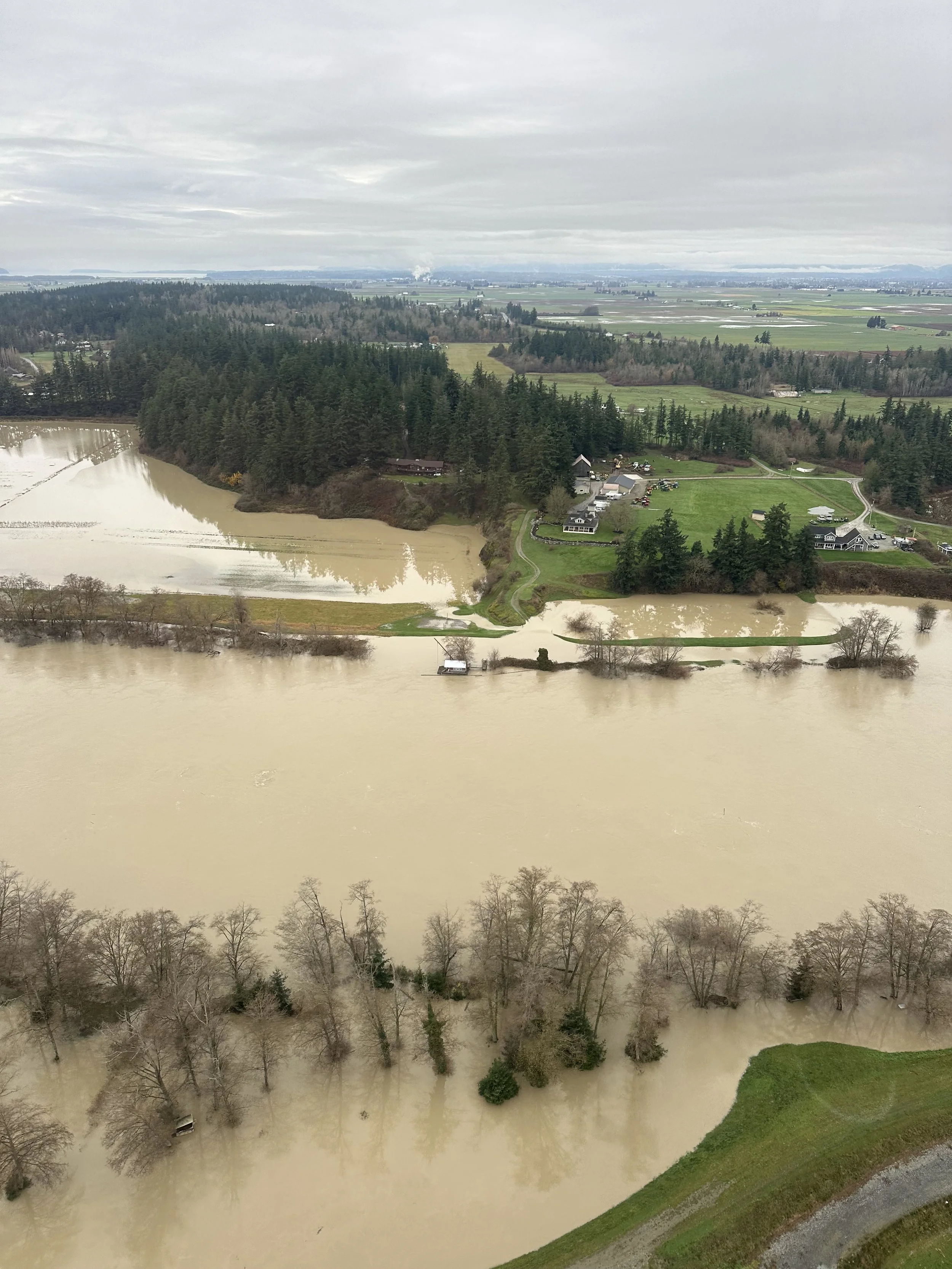
Helicopter view of the Skagit River, December 12, 2025. Photo: Darrin Morrison.
“The only thing that lowered the flood level was storage at the dams,” said Will Honea, who advises the county board of commissioners on natural resources law and policy. Without the dams holding back the floods, “these floods would have been absolutely destructive,” he said.
The official analysis has not yet been released, but it is likely that storage held back seven to eight feet of water. That would have put the river level closer to 45 feet, which would have overtopped the levees and flood walls and been a much bigger tragedy.
The Corps of Engineers assumed control of Seattle City Light’s Ross Dam and Puget Sound Energy’s Upper Baker Dam on December 8. As the river peaked on December 11, Ross Dam outflows were a mere 450 cubic feet per second (cfs) compared to the 50,000 cfs gushing in from the Skagit.
Hamburg echoed Honea’s assessment. He described working with the U.S. Army Corps of Engineers and the Skagit County Department of Emergency Management as “phenomenal.” Years of negotiating with Puget Sound Energy on the Baker River and Seattle City Light on the Skagit River had included communication protocols and a negotiated settlement for more storage capacity behind the dams.
The cooperation and coordination of storage and release is “the difference between us managing this flood and complete catastrophe,” Hamburg said. The dike partnership has worked for decades to improve channels of communication, which “makes us better managers and decision makers by far,” he said, noting greater difficulty during past floods.
—
On Sunday, it was Friebel’s turn to board a Black Hawk and observe the havoc the river wreaked. First, she saw the significant flooding at Nookachamps Creek, a low-lying area that commonly floods in part because of a sharp 90-degree turn in the river. Francis Road, which goes through the area, was under eight feet of water for days.
From the ground, “you really can’t get the full extent of the flooding, but from the air you can,” she said.
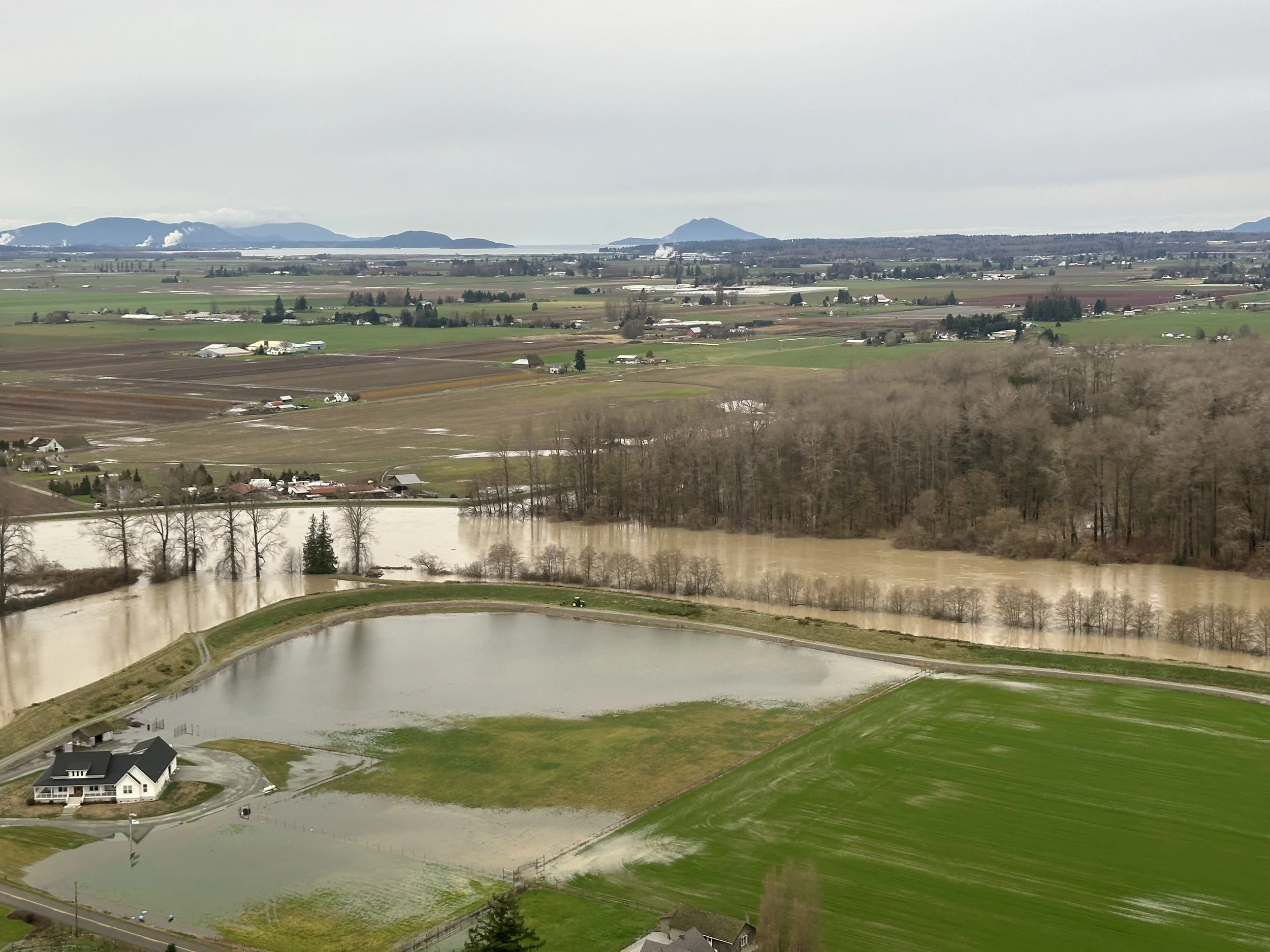
Helicopter view of the Skagit River, December 11, 2025. Photo: Darrin Morrison.
Next, they headed upriver where the breach at Cockerham Island occurred, and on to Concrete where “weather closed in on us,” forcing a change in course. From the air, the damage to Highway 20 was clear.
Flying north, nearly to Canada, over Sumas, Lynden, and Everson, Friebel observed the vast damage to Whatcom County from the flooded Nooksack River. She saw towns and new housing developments built on farmland, now inundated. In contrast to Whatcom, Skagit County’s agricultural preservation and zoning policies have minimized floodplain development. As a result, in the Skagit, Friebel saw plenty of land underwater. But once that land drains, “things kind of go back to business very quickly,” she said.
—
Skagit County has faced floods before, and what officials have learned and built made this one less damaging than it might have been. Yet infrastructure cannot stop all damage. In the valley, seed farmers were hit, and winter grains in fields that did not drain quickly will likely not thrive. In Burlington, Gages Slough flooded homes that had not been touched by past floods. Upriver, the impacts were more severe.
Governor Bob Ferguson declared an emergency while the rain was still falling, which freed up immediate funds. A federal emergency declaration was approved, authorizing the Federal Emergency Management Agency (FEMA) to aid in the flood response. Resources from many organizations and programs are still just becoming available. Farmers and residents can start with Skagit County’s incident page and the Natural Resources Conservation Service, which links to resources. For folks dealing with the aftermath of the flooding, finding the time and the patience to tap these resources can take its own toll.
—
No one can stop future flooding, but measures can be adopted to strengthen preparation and the ability to respond when floods and other disasters come.
The Monday after the river crested, the county commissioners passed an ordinance to create a Climate Impact Advisory Committee. In the works for months, the flood provided a timely reminder that we live amid uncertainty. The committee will focus on “bringing together local Indigenous and scientific knowledge at the interface of science and policy to create community consensus around the problems we’re dealing with,” Honea said. “This flood underscored the need for that.”
Friebel agrees and hopes the group is empowered “to really start to deal with flood risk in an integrated way. We really need to focus the funding resources, focus the technical expertise in a way that is transparent and leads to good long-term policy,” she said.
Smart growth, especially with respect to the floodplain, is one critical aspect of long-term policy. “That’s vulnerable land,” Morrison said. Farmland preservation, an area where the county has a strong track record, is a centerpiece of that effort.
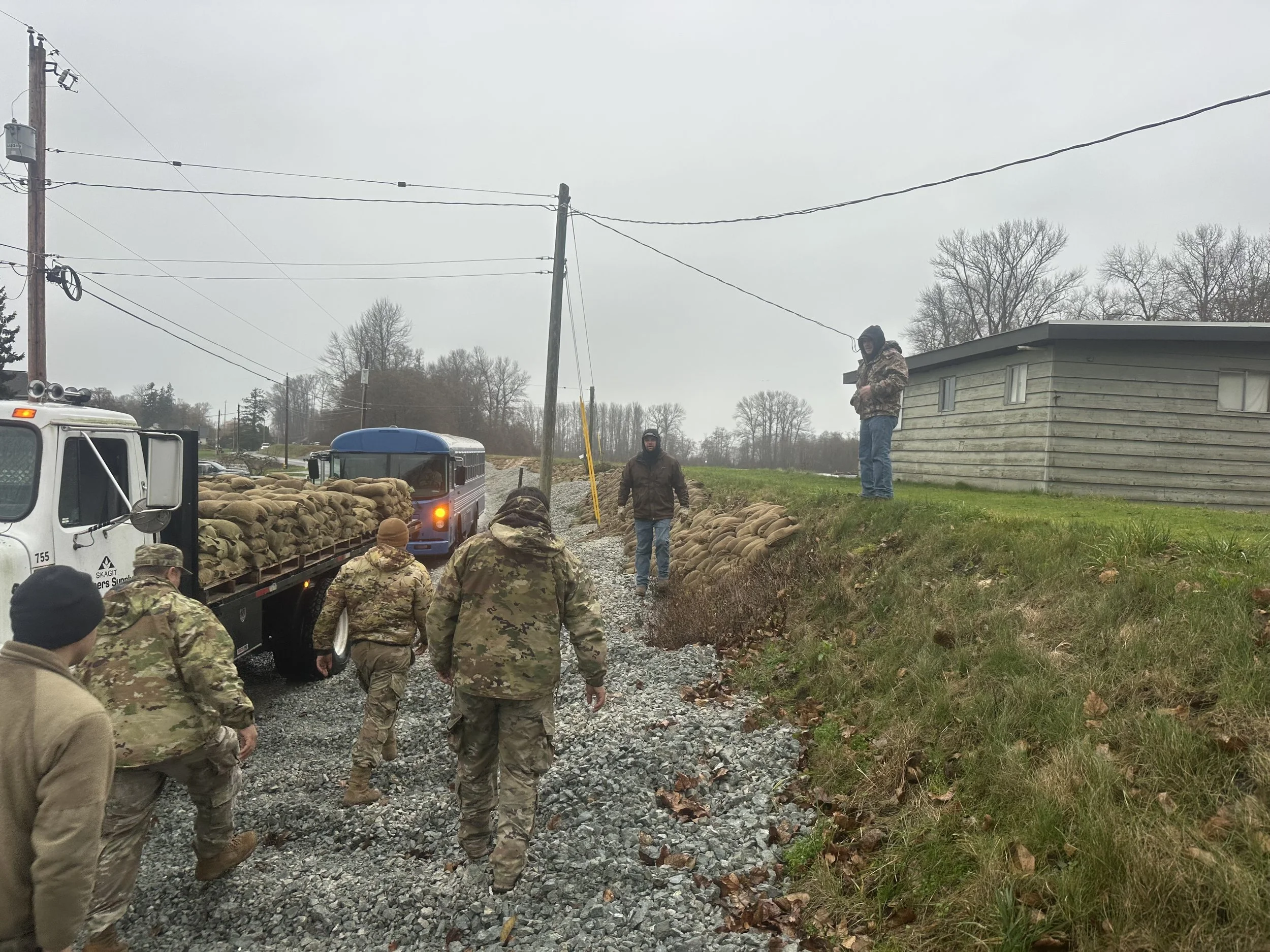
Post-crest flood repair work along road, Skagit, December 18, 2025. Photo: Darrin Morrison.
Living in Skagit long enough, it is easy to forget the levees that protect lives and property.
“When you look at that piece of dirt that’s mounded up by the river,” Hamburg said, “just remember that without that piece of dirt, we wouldn’t be able to farm at the level and quality that we do.”
Story by Adam Sowards: info@skagitonians.org